Cape Town
| Cape Town Cape Town Kaapstad | ||||
Heraldic | ||||
Cape Town | ||||
| Administration | ||||
|---|---|---|---|---|
| Country | ||||
| Province | Western Cape | |||
| Municipality | Cape Metropolis | |||
| Mayor Mandate | Dan Plato (DA) Since October 2018 | |||
| Demographics | ||||
| Gentile | Captonian | |||
| Population | 433,688 hab. (2011) | |||
| Density | 1083 hab/km2 | |||
| Urban population | 3,740,026 hab. | |||
| Geography | ||||
| Coordinates | 33° 55′ 31′ south, 18° 25′ 26′ east | |||
| Area | 40,028 ha = 400.28 km2 | |||
| Location | ||||
| Geolocation on the map: Western Cape
Geolocation on the map: South Africa
Geolocation on the map: South Africa
| ||||
| Links | ||||
| Website | www.capetown.gov.za | |||
Cape (in Afrikaans: Kaapstad, in English: Cape Town, in xhosa: iKapa) is a town in South Africa, capital of the Cape Town colony (1652-1910) and then of the Cape Province (1910-1994). It is currently the provincial capital of Western Cape.
Since 1910, Cape Town has also been the parliamentary capital of the country, alongside Pretoria (administrative capital) and Bloemfontein (judicial capital).
The city of Cape Town, founded in 1652, is considered the mother city of South Africa. The southernmost city on the African continent, it is located on the shores of Table Bay and is topped by Table Mountain with two peaks named Lion's Head and Devil's Peak. The city was named after the Cape of Good Hope, discovered by the Kingdom of Portugal, located more than 47 kilometers south of its historic center.
Geography: from the city to the metropolis of Cape Town
The town of Cape Town was originally built on the southern shores of Table Bay at the foot of Table Mountain, which itself lies north of the Cape Peninsula, completed by the Cape of Good Hope at the southwestern tip of the African continent. The city is 400 miles west of Port Elizabeth and 800 miles southwest of Johannesburg.
Today, the metropolis of Cape Town encompasses all of these territories as well as those stretching over the Cape Flats (the "Cape Plain") to the south to the outskirts of False Bay, and to the east to the Hottentots-Holland (en), the western part of the folded belt of Cape Town (Cape Fold Belt).
The historic city of Cape Town is the City Bowl, which together with several suburbs formed the City of Greater Cape Town in 1913.
The city incorporated several suburbs and communes during the 20th century before forming in 2000 the present metropolis of Cape Town called City of Cape Town, composed of six former administrative entities.
City Bowl
The City Bowl is a natural amphitheater located between Table Bay, Signal Hill, Lion's Head and Devil's Peak Mountains. This is the historic center of Cape Town. Organized around the gardens (Company's Garden, the Parliament) and the business district (Cape Town City Center), Cape Town's harbor, the Victoria & Alfred Waterfront, the Fort of Good Hope and the residential districts of Bo-Kaap, De Waterkant, Higgovale, Oranjezicht, Salt River, Schotserche Kloof, Tambovale skloof, University Estate, Vredehoek, Walmer Estate, Woodstock and Zonnebloem (ex-district Six).
South and Atlantic suburbs
In 1913, the city of Cape Town absorbed the towns and seaside resorts located in the south-west, on the Atlantic coast: Bantry Bay, Camps Bay, Clifton, Fresnaye, Green Point, Mouille Point, Sea Point and Three Anchor Bay. Hout Bay and Llandudno joined the metropolis in 2000.
The suburbs of the southeastern suburbs of Cape Town are mainly residential neighborhoods integrated into the city of Cape Town as early as 1913 or during the twentieth century: Rondebosch, Claremont, Plumstead, Mowbray, Observatory, Ottery, Pinelands, Wynberg, Newlands, Bergvliet, Constantia and Bishopscourt.
North suburb
The districts and suburbs of the northern suburbs of Cape Town are inhabited by a predominantly Afrikaan-speaking population. These are the districts and suburbs of Bellville, Bothasig, Brooklyn, Burgundy Estate, Durbanville, Edgemead, Elsie's River, Factreton, Goodwood, Monte Vista, Panorama, Parow, Richwood, Thornton, Table View and Welgemoed. With the exception of Kensington and Maitland, which are integrated into Cape Town, most of these neighborhoods are attached to the Metropolitan Municipality.
West Coast
The west coast suburbs, located beyond the northern suburbs on the Atlantic coast, include Bloubergstrand, Milnerton, Tableview, West Beach, Atlantis, Melkbosstrand, Big Bay, Sunset Beach, Sunningdale and Parklands.
East suburb
This area includes the suburbs of Fairdale, Brackenfell, Kraaifontein, Kuils River, Blue Downs, Belhar and Protea Hoogte.
Southern Peninsula
The Cape Peninsula, more rural but urbanizing, has been an integral part of Cape Town's metropolis since 2000 (with the exception of Kalk Bay, integrated into Cape Town in 1913). There are several renowned seaside resorts and fishing ports such as Hout Bay, Muizenberg, Noordhoek, Fish Hoek, Kommetjie, Scarborough, Simon's Town, St James, Sun Valley and Steenberg.
Helderberg
This eastern suburb of the peninsula includes the seaside towns of Somerset West, Strand and Gordons Bay.
Cape Flats
Cape Flats is a strip of flat land located southeast of Cape Town's central business district. The Cape Flats are one of the legacies of the apartheid era, and more specifically the Group Areas Act. The populations that reside there are almost exclusively those of non-European origin. It is a particularly dense area, including slums, where the most disadvantaged populations of Cape Town live. The Colored neighborhood is home to the residential, industrial and commercial Colored neighborhood of Athlone, the colored township of Mitchell's Plain and the informal township of Khayelitsha for black people.
Demographics
At the end of the apartheid period, Cape Town is a predominantly mixed-race metropolitan area (50%) with a white minority (27%) and a black minority (23%).
The population of Cape Town increased by 36% between 1996 and 2001. The share of the black population in total residents during this period experienced an exceptional increase of 89.4% compared to 24% for the white and colored (metis) populations. This population increase is due in particular to an internal migration wave in South Africa, mainly from populations from the Cape East (44%). One of the main causes of this internal emigration to Cape Town is the end of the apartheid policies which aimed, in particular, at limiting the migration to Cape Town and confining the black population to bantustans.
At the time of the 2001 census, the town of Cape Town had 2,893,249 inhabitants, of which 48.1 per cent were Colors, 31.7 per cent were African blacks, 18.8 per cent were white and 1.4 per cent were Asians. The population of Cape Town consists of 52% women and 51.8% individuals under 25 years of age. Since 1996, the year of the previous national census, the black population has increased by 42.3%, the Colored population by 12.3%, the Asians by 9.6%, while the white population has decreased by 0.2%.
In 2007, the town of Cape Town had approximately 3,497,000 inhabitants, of which 44 per cent were Coloureds, 35 per cent were black and 19.3 per cent were white. In 2011, the town of Cape Town had 3,740,026 inhabitants, of which 42.4 per cent were Colored, 38.6 per cent were black and 15.7 per cent were white.

The mother tongue of Cape Town residents is English (51%) followed by Afrikaans (43.72%). At the urban level, the majority of the residents' mother tongue is Afrikaans (41.4%) followed by English (27.9%) and Xhosa (28.7%), which have risen sharply since the last waves of migration.
About 69% of the population is between 15 and 64 years old compared to 5.5% over 65 years old. The average age of residents is 28 years (26 years for blacks and 39 years for whites in 2007).
The unemployment rate is 23.8% in 2011, compared to 24.5% in 2007. Approximately 34.54% of these unemployed are black (39.7% in 2007) compared to 23% of Coloureds (21.8% in 2007) and 4.71% of Whites (4.4% in 2007). There are also 34.7% of people who are not economically active, without being classified as unemployed.
Christians make up 77% of the population compared to 10% of Muslims (the Malays of Cape Town) in 2007.
In 2006, the Cape Town Municipality admitted a shortage of 260,000 dwellings, while the area receives approximately 48,000 immigrants each year from poorer provinces. This rampant immigration is shaking demographic balances. The largest township in South Africa, the Khayelitsha neighborhood, is located on the outskirts of Cape Town.
The mother tongue of the residents of Cape Town, at the urban level, is Afrikaans (34.9%) followed by xhosa (29.2%) and English (27.8%).
Population distribution by neighborhood of Cape Town City (2011)
In the 2011 census, the populations of the main urban areas of Cape Town were as follows:
| Quarters | Urban population 2011 |
|---|---|
| Airlie | 312 |
| Alphen | 754 |
| Bakoven | 2,209 |
| Bantry Bay | 820 |
| Barbarossa | 927 |
| Belle Constantia | 898 |
| Bel Ombre | 1,045 |
| Bergvliet | 4,428 |
| Bishopscourt | 1,603 |
| Buckingham | 361 |
| Cafda Village | 9,964 |
| Bay Camps | 2,773 |
| Cape Peninsula National Park | 1,299 |
| Cape Town CBD | 5,286 |
| Cecilia State Forest | 5 |
| Claremont | 17,198 |
| Clifton | 507 |
| Coniston Park | 1,833 |
| Constantia | 909 |
| Constantia Heights | 763 |
| Constantia Vale | 149 |
| Constantia Village | 73 |
| Crawford | 3,969 |
| Dennendal | 878 |
| Deurdriff | 1,381 |
| Devil's Peak Estate | 1,859 |
| De Waterkant | 361 |
| Diep River | 2,515 |
| Dreyersdal | 2,130 |
| Eagles Nest | 18 |
| Eden Klein | 270 |
| Edward | 148 |
| Elfindale | 2,577 |
| Fairways | 2,952 |
| Ferness | 2,561 |
| Fir Grove | 837 |
| Foreshore | 268 |
| Forest GladeTokai | 217 |
| Frere Estate | 1,081 |
| Fresnaye | 2,011 |
| Gardens | 7,960 |
| Glen Alpine | 50 |
| Glen Valley | 250 |
| Glen View | 689 |
| Graylands | 150 |
| Green Point | 5,362 |
| Heathfield | 4,649 |
| Hout Bay | 17,900 |
| Hope of Constantia | 125 |
| Huis-In-Bos | 357 |
| Kalk Bay | 700 |
| Kenilworth | 10,872 |
| Kensington | 12,551 |
| Kirstenbosch National Botanical Gardens | 24 |
| Kirstenhof | 4,515 |
| Lansdowne | 5,853 |
| Lavender Hill | 25,897 |
| Maitland | 9,782 |
| Maitland Garden Village | 1,834 |
| Meadowridge | 2,519 |
| Moule Point | 1,714 |
| Mowbray | 9,782 |
| Ndabeni | 1,014 |
| Nerissa Estate | 371 |
| Newlands | 5,100 |
| Newlands Forest | 16 |
| Nova Constantia | 448 |
| Observatory | 9,207 |
| Oranjezicht | 3,580 |
| Ottery | 5,089 |
| Ottery East | 2,874 |
| Otyhouse Estate | 37 |
| Oude Molen Village | 530 |
| Pinati | 5,122 |
| Pinelands | 14,198 |
| Plumstead | 20,178 |
| Pollsmoor | 2,161 |
| Porter Reform Estate | 563 |
| Retreat | 25,745 |
| Romp Vallei | 6,352 |
| Rondebosch | 14,591 |
| Rondebosch East | 4,633 |
| Rosebank | 4,963 |
| Royal Cape | 656 |
| Rust-In-Verde | 488 |
| Salt River | 6,577 |
| Schotsche Kloof (including Bo-Kaap) | 3,203 |
| Sea Point | 13,332 |
| Seawinds | 6,700 |
| Sheraton Park | 3,711 |
| Signal Hill Nature Reserve | 11 |
| Sillery | 213 |
| Silverhurst | 1,222 |
| Southfield | 7,106 |
| Steenberg | 4,168 |
| Steenberg Estate | 796 |
| Sunlands | 1,540 |
| Sweet Valley | 331 |
| Bay Harbor Table | 431 |
| Mountain Nature Reserve Table | 58 |
| Tamboerskloof | 2,984 |
| The Vines (Constatia) | 674 |
| Three Anchor Bay | 2,225 |
| Tokai | 2,568 |
| Turf Hall | 848 |
| Turf Hall Estate | 3,933 |
| University Estate | 987 |
| University of Cape Town | 471 |
| Victoria & Alfred Waterfront | 1,570 |
| Vredehoek | 3,556 |
| Walmer Estate | 2,325 |
| Westlake 1 | 6,501 |
| Wetton | 3,300 |
| Windermere | 11,610 |
| Witteboomen | 440 |
| Woodstock | 9,345 |
| Wynberg | 14,472 |
| Yorkshire Estate | 3,056 |
| Youngsfield | 231 |
| Zonnebloem | 5,122 |
| Total City | 433,688 |
Climate
The climate is Mediterranean. The winters (i.e., the summers of the northern hemisphere) are mild and humid, and summers (in winter in the northern hemisphere) are hot and dry. The sunshine is important, the rain is short but violent.
After three years of drought, Cape Town had prepared in early 2018 to have its drinking water supplies depleted by August, although it halved its consumption from 1.1 billion in 2016 to about 586 million liters of water per day. But the rains that have returned have allowed the level of dams to rise and the "zero day" is avoided for 2018.
| Month | jan. | Feb. | March | April | May | June | Jul | August | sep. | oct. | Nov | Dec. | year |
|---|---|---|---|---|---|---|---|---|---|---|---|---|---|
| Average minimum temperature (°C) | 15.7 | 15.6 | 14.2 | 11.9 | 9.4 | 7.8 | 7 | 7.5 | 8.7 | 10.6 | 13.2 | 14.9 | 11.4 |
| Average Maximum Temperature (°C) | 26.1 | 26.5 | 25.4 | 23 | 20.3 | 18.1 | 17.5 | 17.8 | 19.2 | 21.3 | 23.5 | 24.9 | 22 |
| Sunlight (h) | 337.9 | 299.9 | 291.4 | 234 | 204.6 | 174 | 192.2 | 210.8 | 225 | 279 | 309 | 334.8 | 3,092.2 |
| Precipitation (mm) | 15 | 17 | 20 | 41 | 69 | 93 | 82 | 77 | 40 | 30 | 14 | 17 | 515 |
Fauna and flora
The region is known for its unique maquis, Fynbos (fine bush, in Afrikaans), a plant formation housing Protea and that grows nowhere else on the planet. These plants are adapted to their arid environment and have evolved into a dry flora.
History
The Cape of Prehistory and the Khoisan
Archeological research attests to the presence of human beings in Cape Town 750,000 years ago, even though the oldest human bones found in the Cape region belong to a Homo sapiens who lived 80,000 years ago. In the caves of the Cape Peninsula, the human remains discovered are between 75,000 and 50,000 years old, while the oldest cave paintings in Fish Hoek are 28,000 years old. The communities that then live in Cape Town are composed of small groups of nomads, mainly hunter-gatherers. 2,000 years ago, they faced the arrival of hunter-gatherer groups from Botswana, who had turned to pastoralism and sheep farming. This distinction between the two aboriginal groups, genetically similar, whose language is characterized by clicks, gave rise to the San (hunter gatherers) and the Khoikhois (sheep and cattle breeders), later referred to as Khoïsan (or Hottentot).
The discovery of Cape Town by Europeans
The first Europeans to discover the site of the future city of Cape Town were Portuguese navigators. Bartolomeu Dias landed in the Cape region in 1488, after having crossed the southwest coast of Africa, and reached the cape of Aiguilles via the high seas. The first to cross the Cape of Good Hope concretely was Vasco de Gama in 1497 while he was looking for a road to lead him to Asia. The name he gave to the cape was at the time that of "Tempest Cape" because the currents are very strong. The King of Portugal renamed him the Cape of Good Hope because he saw it as a new road to Asia and its spices. Table Mountain was named Taboa da caba in 1503 by the Portuguese admiral and explorer Antonio da Saldanha, the first European to dock in Table Bay and climb the mountain. For those who live there, the Khoïsan peoples, this mountain is the Hoerikwaggo.
The area was the subject of regular contacts between Khoi and Europeans throughout the 15th century and the beginning of the 16th century. The circumvention of Africa takes no less than six months per boat and every trip is marked by the death of many sailors because of the lack of fresh products. But the Cape of Good Hope is located halfway between Europe and India. Table Bay, dominated by the massif of the same name from which several rivers descend, then appears to be a suitable area for supplies and trade with the few local populations. But contact with the Khoïsan populations can lead to misunderstandings and bloody outcomes. Attempting to trade and exchange with them, Antonio da Saldanha was seriously injured in an ambush by his interlocutors. In 1510, the Portuguese Francisco de Almeida was massacred with about sixty of his men during a punitive expedition against the Khoitans. During the second half of the sixteenth century, the Dutch, who displaced the Portuguese on trade routes to Asia, tried to establish contacts with the Khoi. But in 1598, 13 Dutch sailors were killed by Khoi in a dispute. In the 1620s, other attempts were made to trade with the Khoi until 1632 and the death of 32 Dutch sailors, victims of the Khoi.
In 1644, the Mauritius Eylant, a ship of the Dutch East India Company (VOC), stranded on the rocks of Mouille Point immobilizing the 250 crew members on the shores of Table Bay for four months. In 1648, the Nieuwe Haarlem, another VOC vessel, also failed at the foot of Table Mountain. The survivors survived there for a year around a fort of fortune, which they called Sand Fort of the Cape of Good Hope, feeding on land products, before being taken to Europe by a passing ship. In his report to the VOC, the commander of Nieuwe Haarlem suggested establishing a refueling station there because the climate is Mediterranean and the soil is fertile.
South African City Foundation

On , a fleet of three vessels (the Drommedaris, the Reijger, the Goede Hoope), commanded by Captain Jan van Riebeeck on behalf of the VOC, landed in Table Bay. Designed to be the Ocean Tavern, the refueling station that it must base on the site that the Khois call Camissa, is intended to be used to replenish ships sailing on the commercial route to Indonesia, to treat scurvy crews and to repair damaged ships. The location was chosen for its sheltered bay, which forms a natural port and protects the boats from the prevailing south-east wind.
Van Riebeeck arrives in the bay with 82 men and eight women, including his wife Maria de la Quellerie. The three ships he commands are joined by two other ships, the Walvis and the Oliphant. In total, the flotilla lost some 130 people during the journey from the Netherlands. Arrived with timber, tools, seeds to be planted and rifles, Jan van Riebeeck built a fort on the left bank of the Salt River and built vegetable gardens and orchards. Fresh water is transported from the mountain through canals to allow irrigation. When Van Riebeeck arrives in Cape Town, between 4,000 and 8,000 Khoïans (Khoi and San), divided into clans, live on the peninsula. No Black Bantou resident less than 600 miles east. Trade relations were established with the new arrivals, with the Khoi agreeing to trade cattle (sheep and cattle) for iron, copper, glass, tobacco and alcohol. There is no notion of private land ownership in the Khoi society, a semi-nomadic people where each clan follows its own migratory route. In particular, the Khoi expect the Dutch to be just passing by, as Europeans have always been in the past.
If was born in Cape Town the first white child of South Africa, the first times in Cape Town were difficult for the Bataves, 19 of whom did not spend the first winter.
Relations between Khoi and Europeans deteriorate quite rapidly, especially after the Khoi discovered that the VOC's men created gardens surrounded by thorny trees on their migratory route. Europeans rely on Khoi breeders to supply them with meat, but they, fearing that their internal political status would be diminished and threatened, end up refusing to sell livestock to Europeans. The Dutch do not understand this refusal they take for an affront. For Van Riebeeck, no relationship of trust can be established with the Khoi whom he perceives as brutal people. Unable to rely on Khoi beef to feed his men, he encouraged the breeding of sheep on Robben Island, located opposite Cape Town, and the hunting of seals, whales and antelopes.

domain of Simon van der Stel.
Van Riebeeck is committed to establishing a rapidly operational refueling station. He needs labor to complete the construction of the fort, the pier, to grow the gardens and develop the infrastructure. However, the Khoe refuse to work for him and the sailors are reluctant to do this kind of activity. He therefore asked the VOC to send him slaves. In 1654, Asians from the Dutch colony of Batavia were deported to Cape Town. Of a Muslim faith, they form a new community, the Malays of Cape Town. The first ship filled with black slaves arrived from Dahomey followed by ships carrying slaves from Angola.
In 1657, VOC issued establishment and farm permits to some of its employees who became the first free citizens of Cape Town (free burghers) who established farms along the Liesbeek River where promising experimental crops were first grown. To work on these farms, slaves from Java and Madagascar are brought to Cape Town. For example, in 1658, of the 162 registered residents, the refueling station had 82 free citizens and civil servants (white) and 80 slaves, but the high death rate of the slaves required a high level of traffic. A total of sixty thousand slaves were deported to Cape Town between 1658 and 1807, the largest contingent being from Sulawesi, Indonesia.
While the VOC demanded in its mission letter to Van Riebeeck not to build a city but only a commercial counter, a boarding school, four taverns, artisans' houses and four streets exist in Cape Town in 1657 in addition to the wooden fort and garden, all designated as Kaapstad or De Kaap (Cape Town) ) by the sailors which alarms the Company.
The year 1658 was marked by the first notable conflict between the residents of the European zone of Cape Town and the natives: the right of access to the land and pastureland of which the Khoi are deprived by the territorial expansion of the Europeans. This first conflict ended with the victory of Europeans, better organized and better armed. Van Riebeeck was determined to ensure security on the peninsula and in 1660 had watchtowers built and a hedge of wild almonds planted to demarcate and separate the European zone (2 430 ha or 6 000 acres) from the territories where the Khoi lived. This landlocked area also includes Saldanha Bay and the islands of Dassen Island and Robben.
When Van Riebeeck left Cape in 1662 to return to the East Indies, the embryonic Cape colony had 134 employees of the East India Company, 35 free settlers, 15 women, 22 children and 180 slaves.
Cape Town's society was already highly hierarchical, diverse, multi-ethnic and stratified. After heavy rains, Van Riebeeck's wooden fort was lost in 1663. VOC administrators then demand that a stone building be built. Work on the first permanent European fortification in South Africa began in 1666 and was completed in 1679, replacing the wooden fort of Van Riebeeck. Called to become the center of the VOC government, the governor's residence, the residence of senior officials, housing offices, a bakery and garrison, it is today the oldest building in South Africa.
Several conflicts still erupted between Europeans and Khoi, notably in 1673 and 1677. Khoi clans, however, are divided and unable to protect their livestock when attacked. With no herds, clan leaders find themselves deprived of their authority, quickly leading to the disintegration of Khoïsan social structures, the dispersion of families, and finally the disappearance of the Khoi from the peninsula. While many leave the Cape region to go north, others serve Dutch farmers (the Boers), often as shepherd.
In 1679, when Simon van der Stel was appointed Commander of Cape Town, the station had 289 European residents including 142 free citizens and 191 slaves. Simon van der Stel has ambitious plans to develop the entire region economically. As soon as he arrived, he sent geologists to explore the region's fertile lands and himself climbed the slopes of the mountains beyond Cape Flats. During one of his hikes in the area, he identified on the banks of the Eerste River suitable land for agricultural operations and decided to build a second colonial home there. Thus the village of Stellenbosch was born, while in the suburbs of Cape Town, Simon van der Stel had a large agricultural estate which he called Groot Constantia and on which he tried to develop wine growing.
In 1685, the permanent residents of Cape Town of European origin were mainly farmers, artisans or handlers. Their education is basic. They were joined in 1688 by 238 French Huguenots, fleeing religious persecutions in France, to whom Simon van der Stel granted land to Olifantshoek, a green valley rich in alluvium, renamed Franschhoek, to develop the vine culture at the request of Simon van der Stel. These newcomers are cultivated and will have a strong influence on South African white culture.
At that time, the estate governed by the Cape Authority extended from Muizenberg on the Indian Ocean to the mountains of Steenberg and Wynberg. Simon van der Stel makes the entire peninsula explore, which allows him to locate a natural port in False Bay, which he calls Simon Bay, which he calls a rescue port for VOC boats.
The capital of the Cape Town colony
In 1691, Cape Town officially became a colony of 1,400 people, or 1,000 white citizens or VOC officials and 400 slaves. In 1693, the first road was built, via Constantia Pass, connecting the mother city to Hout Bay. In 1697, a hospital that could accommodate 225 patients, including sailors passing through Cape Town, was built. In 1699, the new governor, Willem Adriaan van der Stel, Simon's son, undertook to monopolize commercial contracts that provoked a revolt among the population of free citizens and the first nationalist demands. Thus, the young Hendrik Bibault publicly refuses to obey the injunctions of a judge arguing that he was no longer Dutch but African (Afrikaner).
The city of Cape Town spreads throughout the 18th century. During the administration of Maurice de Chavonnes (1714-1724), outposts were to be erected several kilometers from the city, at strategic points in Tulbagh, Klapmuts, Groenekloof and Saldanha Baai to secure the European zone from any Khoi invasion while Dutch farmers venture into more and more areas further away from the port, creating large farms in the Hottentots-Holland mountains or further north in the Swartland. These trekkers, which are moving further and further away from Cape Town, end up in conflict with the Khoi tribes, which are gradually decimated (especially by diseases such as smallpox), forced to work for farmers, or reduced to fleeing north. Vast stretches of land are cultivated and forests planted, while the wild animals of the peninsula such as elephants, antelopes, buffaloes, hippopotamuses and lions are gradually disappearing, victims of hunting and urban expansion. New cities were also created, such as Swellendam (1745), named Henry Swellengrebel, the first colonial governor born in Cape Town, and Graaff-Reinet (1786).
Cape Town, however, is the capital of a colony for which the metropolis has no territorial or civilizing ambition. There are virtually no primary schools, no secondary schools, no missions, and few churches. Local politics and appointments to administrative functions are strictly controlled by the governor. There are no newspapers and no printing facilities. To protect and assert its control, the VOC has a local militia and a garrison of soldiers, mainly of German origin. The castle, for its part, is the symbol of this domination, while the warehouses affirm the exclusive right of the only VOC to trade with the ships
Violators of VOC regulations can be sent to Robben Island prison, sentenced to hard labor, or, in the worst case, sentenced to death by a VOC salary magistrate. The law is also discriminatory and special and very severe treatment is applied to disobedient slaves. In spite of this strict regulation, particularly in the commercial field, Cape Town is considered to be a crossroads of the oceans among sailors and sailors, a city where in shops tobacco, cotton, wine, rice, tea, silk, especially chintz fabric can be found, due to a tolerance accepted by local VOC administrators.
In the 18th century, Cape Town itself was described by travelers as a "pretty" and "neat" city with its straight streets drawn to the curtain, its main street (Heerengracht), its large square (Grand Parade), its castle, its taverns, its workshops, its guest houses, its canal bordered by trees and its gardens. The houses of housing are located away. The architecture of these houses takes on a distinctive style specific to Cape Town (Cape Dutch style), emphasizing the Dutch origin of its inhabitants embellished with Asian influences. The walls are whitewashed, the shutters are painted green and the roofs are covered with thatched. There were more than a thousand such houses in the mid-18th century.
Cape Town is a very cosmopolitan city and port nicknamed the Sea Tavern. VOC employees who settle in or transit through Cape Town, with their wives and children, are largely from Northern Europe (Scandinavia, Russia, England, France, Switzerland, the Random countries and the Netherlands). You will also find many Indian, Javanese or Chinese sailors. Each year, on average, 70 ships anchor in Table Bay to stay moored in general for nearly a month. Warehouses and shipyards are located along the shore. Since Cape Town is the only deep-water port in South Africa, the VOC controls all of the colony's foreign trade.
It was also during the 1750s, since Cape Town, that the French astronomer Nicolas-Louis de Lacaille built an astronomical observatory and produced the first map of the southern hemisphere.
In the 18th century, Cape Town society was highly hierarchical, with VOC officials at the top, at a much lower level, the company's soldiers, and slaves at the bottom. The rules applied aim to instill a sense of subordination among the local population towards the administration of the governor. Thus, for example, no one can marry without the permission of the VOC, while in the church, benches are reserved for civil servants according to a strict hierarchical principle. A dress code is also applied which only allows senior officials to wear velvet and junior officials to wear silver or gold buckle shoes. At the bottom of the social scale, slaves cannot wear shoes. The slaves are mostly from East, West, Southern Africa, Madagascar, but they come from Mauritius, Ceylon, India, Malaysia or Indonesia. In 1708, Cape Town had only 1,700 free citizens for a few hundred VOC officials, 1,250 slaves and a few thousand Métis and Malays.
Political life is extremely embryonic in this society. In 1778, a movement of the Cape Patriots (Kaap Patrioten) emerged, influenced by the ideals of the American revolution and favorable to the establishment of a republic. The movement is mainly demanding political rights and economic freedom.
Cape Town is also characterized by a growing population of Métis, who come from relations between slave women and Khoe women with European sailors or slave owners. In the early years of the Cape Town colony, because there are few white women available, marriages between freed Europeans and slaves or women from Asia are even allowed because it is the economic order that is at the center of the VOC's concerns, not some racial order. Governor Simon van der Stel himself is mixed. Older slaves may even be able to raise themselves socially and obtain a status comparable to that of soldiers through the granting of VOC privileges to those in positions of responsibility. A small minority of "free blacks" coexist with other population groups. They are often freed slaves from Africa or Asia or non-Europeans settled in Cape Town (Chinese). They often live on fishing or craft and enjoy the same status as free citizens of French-Dutch origin. These "free blacks", slaves, bourgeois and sailors can mix and mingle in taverns, drink together, dance and play games. However, gradually, through the granting of privileges and the allocation of positions, VOC eventually establishes categories of populations benefiting from discriminatory benefits. The small minority of "free blacks" also ended up being discriminated against at the end of the 18th century with the obligation to have an internal passport (pass) like slaves.
At the end of the eighteenth century, the strategic importance of Cape Town on the route to India was an undisputed fact for Europeans. Thus, as part of the Franco-Dutch alliance, French army troops stationed in Cape Town from 1781 to 1784 to prevent a British invasion. French mercenaries, paid by the VOC, remained there afterwards. The French established a new maritime defense network, while French merchants made Cape Town their bridge for trade in the Indian Ocean and the source of supplies for the French colonies of Île Bourbon and Isle de France. The French influence is also noticeable in the architecture, with the arrival of military engineer Louis-Michel Thibault who works with the German sculptor Anton Anreith on amenities such as the perron topped with a marquise of the Cap Castle and substantial improvements for several buildings such as the Slave Lodge, the Groote Kerk, the Lutheran church and the Koopmans house of Wet. However, the VOC is in decline, competing with the British East India Company, which broke its monopoly on Indonesia and the road to China. It ceased paying dividends to its shareholders in 1782, while the number of its employees in Cape Town exceeded 3,000, and the amount to be paid to pay mercenaries and defend the colony was constantly increasing. Corruption ends to cripple the administration as the autonomist claims of the Trekboers, the majority of whom live outside the city, rise. For example, in the 1780s, of Cape Town's 11,000 to 12,000 free citizens, only 3,000 residents in the South African mother city, forming the majority of the permanent white population (4,300).
At the twilight of the Dutch Cape Town administration, a new indigenous population, stratified into different, multi-cultural, poorly educated and mostly poor, cut off from its European origins, developed at the southern tip of Africa. It is a society based on cheap labor and slavery. There are also many Asians and Métis whose status varies depending on their economic contribution. As for the Khoisan populations, they were pushed out of the peninsula towards the deserts of the Karoo and Namib. One of the unexpected legacies of this first part of Cape Town's colonial history is the emergence of a new language, Afrikaans, a Dutch language modified by words borrowed from several different languages (Khoïsan, Arabic or Malay). Cape Town, for its part, is a very active and strategic port as the British come to take possession of the mother city of South Africa.
Cape Town Under British Rule
The first British incursion into Cape Town took place in July 1795. Following the French Revolutionary Army's invasion of the Netherlands, a British force under the command of James Henry Craig was sent to Cape Town to protect the Dutch colony from the French. The squadron docked at Simon's Town whose fortifications were neglected. After a few skirmishes, Cape Town's defense forces went to the British who occupied the colony.
Cape Town then had 14,021 inhabitants, of which 4,357 were European, with the Cape colony as a whole having 16,839 slaves and about 16,000 residents of European origin.
The British occupation ended in 1803 when Cape Town was returned to the Batavian Republic (Peace of Amiens). But, following the return of hostilities in Europe, the British were forced to re-engage. Following the Battle of Blaauwberg on , Cape Town again came under British control. The first temporary occupation became final in 1814 (Congress of Vienna).
In the early years of the British occupation, the old administration retained its prerogatives, including commercial prerogatives, while the Romano-Dutch legal system was maintained. In 1820, there were only 757 Britons who were listed as permanent residents of the Cape Town colony for a total of 25,000 free subjects, 30,000 slaves and some twenty thousand Khoysan. Gradually, English began to replace Dutch as an administrative language, while the British East India Company (BEIC) began to settle in Cape Town. Cape Town's merchants and merchants thrive quickly thanks to the extensive world-class trading network built around the British Empire. Cape Town exports fruit, wheat, wine and wool, and imports coffee, horses, wood and coal. British traders settled in Cape Town, with the active support of a London-based company, the Cape of Good Hope Trading Society, and quickly formed a wealthy class, stimulating exchanges that put an end to the VOC's old monopoly practices. By the 1820s, these merchants became the backbone of a new and powerful Cape middle class. Fewer than the Dutch, they are more active and energetic and invest in the modernization and development of Cape Town's port infrastructure and obtain the relaxation of controls to allow the creation of private banks (1837). The spearhead of progressive social ideas, they brought a breath of Anglo-Saxon liberalism to Cape Town, characterized in 1824 by the publication of the first local newspaper, the South African Commercial Advertiser, which struggles for the emancipation of slaves, the liberalization of trade, the development of infrastructure, the development of health care, the literacy of populations or self-government. In the end, through a dynamic civil society, the aim is to transform a rural Dutch town into a true colonial capital worthy of the British Empire.
In 1836, the abolition of slavery in the Cape Town colony accelerated the economic and social transformation of the City. A new, more complex society begins to take shape. Remuneration for the emancipation of slaves contributes to the expansion of a new urban middle class and to the growth of labor. At that time, the British introduced the term Colored to refer to non-Europeans as a whole but distinguished the Malays of Cape Town (6,000 in 1840) to refer specifically to Muslims who were assigned to Cape Town in a specific neighborhood called Bo-Kaap. Socially, there are no reserved jobs and all occupations are mixed, especially between white and mixed-race, as are housing estates, especially those of the working class. Inter-racial marriages (primarily Métis and White) are also legal. In the absence of restrictions on construction (introduced only in 1861), many cheap houses, separated by narrow alleys and without any basic comfort (without sewage), are built for the former slaves and the poorest, especially in District 6.
As the first Cape Town Legislative Council elections (1836) are held, the number of corporate corporations is increasing as the number of private enterprises increases and more and more residents gain access to real estate or land. In 1845 the first insurance company in South Africa, Mutual Life, was founded.
When the Cape Town municipality was established in 1840, the city had only 20,000 inhabitants, of which 10,560 were white. It then integrates the suburbs of Green Point and Sea Point. The municipality was divided into six districts and in 1867 had three councilors per district. The method of election of councilors is non-racial but based on a franchise: to be an elector, you only need to have income and own in Cape Town.
In 1849, the British proposal to establish a penitentiary colony in Cape Town was strongly contested by the population that stopped the initiative. Part of Heerengracht Street, the central axis of Cape Town, is renamed Adderley Street in honor of the British MP who supported the Cape Town protests.
In 1859, the first railway between Cape Town and Stellenbosch, Parl and Wellington began construction. In 1860 Cape Town had five local banks and several insurance institutions.
From 1860 to 1870, work was carried out on the docks of Table Bay (Alfred Dock). Following the discovery of diamonds in the hinterland in 1867, the Alfred Harbor Basin was the point of entry for the unprecedented trafficking of men and supplies into the Kimberley diamond fields in the 1870s. Large amounts of money and capital are being invested in a few years by banks and businesses in London, allowing Cape Town's economy to increase fivefold in five years, marked by a dramatic increase in the number of companies per share.
In 1863, the first horse tram came into service and connected Adderley Street and Somerset Road to Green Point.
In 1867, the Parliament of the Colony delegated to the municipality all the skills necessary to fully manage the city. The municipal assembly now consists of 18 municipal councilors and a president of the municipal assembly (with the title of mayor) elected by his peers (Cape Town Municipality Amendment Act).
In 1879, a new tram line was established between Green Point and Sea Point and later extended to the Gardens area and the southern suburbs. The following year, Cape Town was connected to Europe by telegraph.
In 1881, separate municipalities were established in the suburbs of Cape Town (Woodstock, Rondebosch, Claremont, Newlands, Wynberg and Kalk Bay). The city's infrastructure is being modernized (roads, electrified tramway, development of water and sanitation networks). The city and the municipality grow as the new neighborhoods of its urban area are connected.
In 1882, Dutch was admitted as the official language of the administration alongside English.
In 1884 the buildings of the parliament of the Cape Town colony were inaugurated.
In 1887, Victoria Road connects Hout Bay by a toll road. Three years later, the pavement of the streets of Cape Town began.
In 1894, the municipality authorized the concession of public transport to an electric tramway operator (Metropolitan Tramways Company). The following year, the city's streetlights were electrified, and in 1896 the first electric tram came into service from Adderley Street to Mowbray Hill.
In 1899, Green Point Common was transformed into a military camp (Second Boer War).
In 1901, the tram line from Camps Bay to Sea Point was extended to the following years.
In 1905, Cape Town was declared the legislative capital for all South African colonies.
Grand Cap, the legislative capital of South Africa
In 1910, Cape Town became the legislative capital of the fledgling South African Union. The Parliament building, built for the administration of the Cape Town colony, became the new parliament of the Union while Pretoria became the administrative capital. The economic activity of the port is decreasing and is outpaced by that of Durban. Cape Town is home to a massive new Italian Renaissance town hall (Cape Town City Hall on Darling Street).
In 1913, the Cape Town Municipality expanded and became the City of Greater Cape Town, comprising the historic center of Cape Town (City Bowl), amalgamated with the suburbs of Green Point, Sea Point, Woodstock, Maitland, Mowbray, Rondebosch, Claremont and Kalk Bay. In 1927, Wynberg was annexed to the city.
Cape Town Under Apartheid
Although the first black Africans residing in Cape Town were slaves imported from Madagascar, Mozambique or East Africa by the Compagnie des Indes Orientales, the first Bantu populations, originally from South Africa, settled in Cape Town only in the 19th century and were refugees from Mfecane. Several small waves of migration will follow over the following decades. When these populations do not live in rural areas, they reside in generally unsegregated neighborhoods, especially in the city center. There are no regulations requiring them to reside or not reside in a particular neighborhood. From 1879 onwards and even more following an epidemic of smallpox and a plague epidemic that ravaged Cape Town in the late nineteenth century, the areas where black people are numerous are perceived by the white and mixed-race population as the source of infections. Victorian speeches on urban health and safety, supported in particular by the clean party, bring together so-called uncivilized populations, hygiene and cleanliness. The solution then comes from segregation of populations. At first, slums are razed and people are expelled, especially in Woodstock. In 1901, a municipal decree in the city of Cape Town first gave the black population of Cape Town an exclusive compulsory residence area: Ndabeni. At that time, Cape Town and the neighboring municipalities of Woodstock, Maitland, Mowbray and Sea Point had only 10,000 bantuphone inhabitants. This population is going to experience significant uninterrupted population growth. In 1927, the first township of Cape Town was built in Langa to compensate for the lack of housing in Ndabeni, which was finally demolished in 1936.
In 1948, the victory of the national party in the South African general elections led to the establishment of apartheid in South Africa, i.e. to a policy involving, inter alia, institutional and systematic racial segregation in all public places. The new legislation includes the distinction of all South Africans between different racial categories. In Cape Town, where many residents come from inter-racial lines, the policy is primarily aimed at separating white and Métis on one side of black people on the other side, and at giving the first two groups distinct advantages over the third population group. By applying the Group Areas Act, the suburbs of the city are zoned by race, with whites being the most privileged category in terms of space and public service.
Since 1976, the laws of apartheid were no longer strictly applied to Cape Town in sports activities and leisure activities. Hotels, restaurants and theaters are frosted and open to all. In 1977, the bus service, in turn, abandoned its segregationist regulation, but quietly, avoiding the attention of the pro-apartheid government of John Vorster. Shortly thereafter, the city of Cape Town opened the beaches under its jurisdiction to the entire population without distinction of race. However, there is no real or visible impact that would allow de facto segregation to continue. Moreover, the racial separation of places of residence and places of schooling was maintained throughout the 1980s. In the September 1989 elections, all of Cape Town's constituencies (city bowl, southern and atlantic suburbs) were won by the Democratic Party, with the notable exception of the northern suburbs, which were anchored in the National Party.
Cape Town in Post-Apartheid South Africa
In 1995, the reform of local governments abolished all the old municipal structures that had been formed since 1910 and established transitional municipal structures. Cape Town was thus led until June 1996 by a City of Cape Town Transitional Council. In 1996, the Cape Metropolitan Area was placed under the authority of a metropolitan council (the Cape Metropolitan Council) and divided into 6 municipal substructures:
- the municipality of Cape Town (City of Cape Town Municipality) which succeeds the former City of Greater Cape Town with the City Bowl (De Waterkant, Foreshore, Gardens, Higgovale, Oranjezicht, Salt River, Schotsche Kloof, Tamboerskloof, University Estate, Vredehoek, Walmer Estate , Woodstock, Zonnebloem), the suburbs of Camps Bay, Clifton, Fresnaye, Green Point, Sea Point, Mouille Point, Maitland, Mowbray, Rondebosch, Claremont, Pinelands, Athlone and the townships of Langa, Nyanga, Philippi, Gugulethu and Mitchell's Plain.
- the Southern Municipality of the Peninsula (South Peninsula Municipality): Hout Bay, Llandudno, Bergvliet, Wynberg, Constantia, Fish Hoek, Kommetjie, Noordhoek, Simonstown, Muizenberg and the townships of Ocean View, Grassy Park or Masiphumelele.
- the municipality of Blaauwberg (Blaauwberg Municipality): Milnerton, Mamre, Alantis, Pella, Melkbosstrand and Bloubergstrand.
- the municipality of the city of Tygerberg (City of Tygerberg Municipality): Bellville, Bothasig, Durbanville, Fisantekraal, Goodwood, Parow, Delft, Elsie's River, Khayelitsha and Mfuleni.
- the municipality of Oostenberg (Oostenberg Municipality): Kraaifontein, Brackenfell, Kuils River, Blue Downs, Blackheath and Eerste River.
- the municipality of Helderberg (Helderberg Municipality): the seaside towns of Somerset West, Strand and Gordons Bay as well as the village of Macassar and the township of Nomzamo.
In 2000, all of these municipal substructures were merged with the Cape Metropolitan Council to form the new Town of Cape Town (City of Cape Town) municipality administering the entire Cape Town metropolitan area.
Cape Town has not experienced major social upheavals following the end of white domination. The growing crime rate does not reach the proportions of other major cities in the country. The policy of the government of national union aims to allow rapid racial mixing in public schools and hospitals formerly reserved for white people, but it fails to allow such a development in private institutions. The poorest whites, however, are sometimes forced to move to more affordable neighborhoods, often formerly classified as metis (Ottery or Rondebosch East), while the colored ones, if they can afford it or have the opportunity, move to neighborhoods where their parents had been forcibly displaced under apartheid (Kenilworth, Mowbray, Sea Point, Wynberg, Woodstock). The wealthiest Blacks are also trying to make a place in the old white neighborhoods like Thornton, while in the university neighborhood of Rondebosch and Claremont, students are contributing to the creation of racial diversity. In the Cape Flats, the end of migration control is contributing to an unprecedented population increase in the black population, particularly xhosa, on the Cape Peninsula.
However, Cape Town, with its liberal and progressive reputation during the twentieth century, is sometimes referred to at the beginning of the twenty-first century as "the last bastion" of South African whites, particularly because black people, some of whom perceive themselves as second-class citizens, are a minority there and continue to feel discriminated against in restaurants or nightclubs and do not go to the beaches that were once forbidden to them, such as those of Camps Bay, frequented mainly by white people. The only major metropolis in the country led by the Democratic Alliance, its leaders are accused by the ANC of maintaining the racial geography of the apartheid era: the whites in the center of town and in the suburbs close to the mountainside and the others mainly in the Cape Flats. President Jacob Zuma calls "extreme apartheid" to describe Cape Town's social system. For the leaders of the Democratic Alliance, and especially for the mayor (colored) of Cape Town, Patricia de Lille, calling the racist Cap de Ville is just a strategy of the ANC to stigmatize the only metropolis that the ruling party in Pretoria does not control.
A study by the Mexican agency Citizen's Council for Public Security and Criminal Justice classified Cape Town as the world's eighth most dangerous city in 2019, and even the most dangerous non-American city in the world (the 7 most dangerous cities that year were all American including 6 Mexican), with 68,28 homicides per 100,000 This is the eighth homicide rate for the highest city in the world and the highest in Africa that year. In addition, with 3,065 murders, the city experienced the world's most absolute homicides in 2019.
Administration
The city is politically liberal during the apartheid years. Nelson Mandela was imprisoned on an island near Cape Town, Robben Island, before being transferred to a prison near Parl.
Frank van der Velde, the mayor of Cape Town from September 1991 to September 1993 under the colors of the Democratic Party, joined the ANC on , just over a month after the first multi-racial elections of . Populated mostly by English-speaking whites and Afrikaan-speaking Métis, the city has nevertheless become an opposition stronghold since the elections.
In the December 2000 municipal elections, Peter Marais, a candidate for the newly formed Democratic Alliance (DA), was elected mayor of the newly formed Cape Town municipality, based on the foundations of several former local municipal entities, including the Grand Cap city. Involved in a political scandal, he was indirectly responsible for the crisis at the end of 2001 which led to the split of the DA and the rapprochement of the New National Party with the ANC. Marais was then replaced by Gerald Morkel (DA), who soon had to give way to Nomaindia Mfeketo (en), an ANC elected official, following the redistribution of seats in the city assembly.
In the municipal elections of , with 37.91% of the votes and 81 seats, the ANC was defeated by the Democratic Alliance (41.85% and 90 seats). This is the ANC's only major defeat in an election that saw its national score increase by ten points.
Nevertheless, with the relative majority of 90 seats out of 210, the Democratic Alliance is dependent on the smaller parties, including the independent democrats (10.5% and 23 seats) led by Patricia de Lille and the African Christian Democratic Party (3.22% and seven seats). The rest of the assembly is divided into the African Muslim party (three seats), the United Democratic Movement (two seats), the Freedom Front (one seat), the Pan African Congress of Azanie (one seat), the United Independent Front (one seat) and the universal bet (one seat).
On , Helen Zille (DA) was elected mayor of Cape Town by 106 votes to 103 in Nomaindia Mfeketo (ANC). She then became the only white woman to lead one of South Africa's six largest metropolises. It is supported by elected representatives of the African Christian Democratic Party (ACDP), the Freedom Front (FF+), the UDM, the Muslim Party, the United Democratic Front and the universal party. Andrew Arnolds (ACDP) was elected as the first deputy while Derrick Smith (FF+) was elected spokesperson for the municipality. A year later, the independent democrats, in turn, joined the municipal majority before merging with the DA.
In the municipal elections in May 2011, the Democratic Alliance won the Cape Town municipality with 61.09% of the votes (135 seats) compared to 33.03% at the ANC (73 seats). She won a major re-election in the 2016 municipal elections and re-elected Patricia de Lille as mayor for a second term, which was cut short in 2018. The current mayor is Dan Plato (DA).
Tourism


In the early 2010s, Cape Town is a major tourist hub in South Africa, offering visitors a wide variety of activities such as water sports (including scuba diving, surfing, sea kayaking, kitesurfing and boating), angling, wine tasting in the Stellenbosch region, shopping, scenic routes including the famous Chapman's Peak Road, mountaineering, booster, kite, hang gliding and paragliding and bird, shark or whale watching near Hermanus.
The most pleasant period is summer, from October to March, although some visitors can't stand the heat of January and February. At the end of the year, cities become overcrowded as local holidaymakers go down to town during their summer holidays. Cape Town is known for its colonial architecture known as Cape Dutch (colonial architecture of Cape Town) and Victorian. The most typical neighborhoods in this area are those of Constantia and downtown and on Long street.
The most popular tourist attractions in Cape Town are the Victoria & Alfred Waterfront, the Aquarium of Two Oceans, Table Mountain (one of the seven new wonders of nature), Camps Bay, Sea Point, downtown, Hout Bay, Constantia, Rondebosch, Newlands, Somerset West, Kirstenbosch Botanical Garden, Cape Town of Good Hope and Hermanus.
The visit to Cape Town's city center usually begins from Heerengracht Square at the site of the first camp of the Compagnie des Indes Orientales where the statue of Jan van Riebeeck has stood since 1899 and that of his wife Marie de la Queillerie (since 1954). The main points of interest which are then accessible on foot are:
- the Civic Center which houses the municipality;
- the Artscape (formerly Nico Malan) Opera House and Theater;
- the castle of Good Hope (1666), residence of the first governors of Cape Town, built in one year according to a star plan. The ceremonial room and other pieces of the fortress contain the William Fehr collection, which includes furniture, paintings and porcelain, as well as a military museum. The flags of the former colonial administrations and of South Africa float on the rampart at the entrance to the fort;
- the Cape Town Town Town Town Hall (1905) near the fort is in Renaissance style;
- Adderley Street, Cape Town's main shopping street;
- the Mutual Building, an Art Deco residential building built in 1939, formerly the headquarters of the Old Mutual Company;
- the Groote Kerk (1836), a Dutch reformed church;
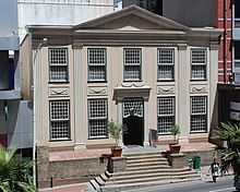
- the museum of history and culture (1679). Built to house the slaves of the East India Company and then the seat of the Supreme Court from 1809, it is, after the castle, the oldest building in South Africa;
- the statue of Jan Smuts located near the Museum of History and Culture;
- Government Avenue, a pedestrian walkway bordered by oaks of the 17th and 18th centuries, bordering the Compagnie gardens where the vegetable garden and orchard Jan van Riebeeck had built in 1652. A statue of Cecil Rhodes is located in the middle of the garden, while paths lead to greenhouses and rose groves;
- Saint George Cathedral (1901), Anglican church;
- the South African Public Library, considered one of the largest libraries in the southern hemisphere;
- the parliament buildings (1885) in front of which stands a statue of Queen Victoria and an equestrian statue of General Louis Botha;
- the South African Museum (1825) is dedicated to the ethnology and natural history of the country;
- the South African National Gallery presents mainly works by South African artists and European collections. Another statue of Jan Smuts, more figurative, stands in front of the building;
- the Jewish Museum (1862), located in the oldest synagogue in South Africa;
- Rust-en-Vreugd (1777), an old bourgeois residence typical of Cape Town, which contains part of the William Fehr collection as well as a collection of ancient South African paintings and engravings;
- Old Town House (1755), former guard post, then town hall from 1761 to 1905. Today it presents a collection of Dutch and Flemish paintings from the 17th century;
- Koopmans de Wet House (1701) on Long Street and Corner Street, bourgeois houses typical of Cape Town in the 18th century with a collection of furniture in the Afrikaner style;
- the Cape Town Holocaust Center (1999), is a museum on the Holocaust, it is the first on this theme in Africa.
The Malay neighborhood is more remote and stretches over Signal Hill. The Bo-Kaap district (17th century) is a listed historic site, recognizable by its pastel-colored houses and minarets. The Bo-Kaap-Malay-Museum is located on Wale Street.
Cape Town is South Africa's second largest port of passengers and merchandise. An entertainment district was built there in 1988 along the Victoria & Alfred Waterfront. A museum of African contemporary art, the Zeitz MOCAA, has replaced ancient grain elevators. The site features an imposing shopping center, luxurious hotels, souvenir shops, restaurants and an aquarium (the Two Oceans Aquarium). From this Waterfront, visitors can take a boat trip to Robben Island, visit the Duiker Island sea lion colony, or take a ferry to Hout Bay or Simon's Town.
To enjoy a beautiful panoramic view of Cape Town, the Table Mountain plateau (1087 m high) is accessible by cable car or by footpaths (about 3 hours). The operating condition (open or closed) of the cable car is reported on a warning sign at Kloof Nek.
The Lion's head is an interesting point of view also to have a superb view of the city center, the beaches, the stadium. Climbing is easy in a good hour and the reward is high. It is common to do this little hike on full moon days to see the sun setting on one side and the moon appearing in the sky on the other.
In the residential suburbs of Cape Town, Groot Constantia, once the residence of Governor Simon van der Stel, is one of the most beautiful examples of Afrikaner architecture. Further north is Groote Schuur (large barn) and on the mountain side are the Kirstenbosch National Botanical Garden, the University of Cape Town buildings, a zoo and a windmill. The Rhodes Memorial, a granite monument of classical Greek inspiration dedicated to Cecil Rhodes and located on the slope of Devil's Peak, offers a beautiful panorama of the city.
The beaches of Sea Point, Clifton, Camps Bay and Llandudno on the Atlantic Ocean are located in the residential area of Cape Town. They are dominated to the east by "the mountain chain of the 12 apostles".
A panoramic Chapman's Peak Drive runs along the Cape Peninsula and leads to Cape Good Hope, located in a natural reserve, along the small port of Hout Bay where the cliffs reach 150 m high and overlook the steep sea.
Another road leads from Cape or the peninsula to the seaside resorts located on the south coast to False Bay. The coastal road passes through the resorts and tourist villages of Millers Point, Simon's Town (a Cape penguin colony lives on its rock beach at Boulders Beach), Fish Hoek, Kalk Bay and St. James, to Muizenberg where Cecil Rhodes owned a cottage and died in 1902. 170 km away, beyond the seaside resorts of Strand and Gordon's Bay, is Hermanus’s old restored fishing port.
The N1 national road leads to the wine-growing hinterland. In Paarl, Stellenbosch and Franschhoek, it is possible to visit wine-growing areas and taste the wines of the region.
August and September are the best time to visit the western coast because winter rains make the desert lively and encourage the flowering of wild flowers.
Cape Town's annual carnival, Kaapse Klopse or Tweede nuwejaar, takes place on January 2.
University

The University of Cape Town, founded in 1829 as South African College, is the oldest university in the country. It is located in the Rhodes neighborhood on the slopes of Devil's Peak in the outskirts of Cape Town. With several faculties and several campuses, these are mainly located in the Rhodes neighborhood but also in the outlying districts of Rondebosch, Rosebank and Mowbray, while the medical school is located on the campus of the Groote Schuur Hospital.
Sport
- Rugby union
- Stormers
- Western Province
- Football
- Ajax Cape Town Football Club
- Cape Town City Football Club
- Chippa United
Transport
Urban
Public transport is provided by the Golden Arrow Bus Services (en), which has transported more than 50 million people every year in 1,154 buses, but also by Myciti (the most modern) since the 2010 World Cup.
Railway
Cape Town Train Station is the terminus for all lines of the regional suburban rail network called Metrorail Western Cape (en). It is, moreover, one of the most important stations in South Africa, served by the Shosholoza Meyl (en) , the long distance service of the Passenger Rail Agency of South Africa.
It is also served by the luxurious train that runs from Pretoria: the Rovos Rail.
Air
Before 1995, Cape Town International Airport (IATA code: CPT, ICAO Code: FACT) was formerly known as the DF Malan Airport. It is a modern airport that was completely rebuilt for the 2010 World Cup. The largest international airlines arrive here.
Odonymia
In 2007, some fifteen years after the end of apartheid, a group of historians and sociologists, set up by the municipality, proposed, from a list of 200 proposals, that 39 names of streets and avenues of the municipality be renamed. In March 2008, Helen Zille refused to have these proposals validated because of a lack of consensus, not only in the municipal council but also in the municipal majority where the elected representatives of the Afrikaans language believed that the names of persons of Afrikaans or of names in the Afrikaans language were the main victims of the changes in the name to come. Among the proposals made, changing the name of "Jan Smuts Drive" to "Dullah Omar Drive" was met with the most hostility and misunderstanding. In December 2010, the municipality adopted a new code of ethics for naming. New street names were then proposed and adopted:
| Old street names | New names from 2011/2012 |
|---|---|
| Oswald Pirow street | Christiaan Barnard street |
| Eastern Boulevard | Nelson Mandela boulevard |
| Western Boulevard | Helen Suzman boulevard |
| Square located on St George's Mall | Krotoa street |
| Place located between Civic Center and Artscape Theater Center (Nico Malan Theater Center) | Albert Luthuli |
| Coen Steytler Avenue | Walter Sisulu Avenue |
| Harrier Street | Blue Crane Street (Parklands) |
| Modderdam Road | Robert Sobukwe Road |
| Native Yard 1 | Steve Biko Road |
| Hendrik Verwoerd Drive | Uys Krige Drive |
| Lansdowne Road | Govan Mbeki Road (section between Baden Powell Dr. and Swartklip Rd) Jeff Masemola Road (section between Swartklip and Wetton Rd) Lansdowne Road (section between Wetton and Turfhall Rd) Imam Haron Road (section between Turfhall and Palmyra Rd) |
| Bay Boulevard Table | FW Klerk Boulevard |
| Vanguard Drive | Jakes Gerwel Drive |
| Salazar Square | Hamilton Naki Square |
| De Waal drive | Philip Kgosana Drive |
| Keizersgracht street | Hanover Street (former District Six) |
Films and series shot in Cape Town
- The Cape Town Affair (1967), American film with Claire Trevor, James Brolin and Jacqueline Bisset
- For all the gold of the Transvaal (1979), 6-episode soap opera with Yves Rénier
- Sam and Sally episode Le diamant (1980), French series with Georges Descrières
- Sea Point Days (2008), South African documentary film
- Ingrid Jonker (2011), German-Dutch-South African film with Carice van Houten, Rutger Hauer and Liam Cunningham
- Strike Back: Project Dawn (2011), British series
- Close-up (2012), American film with Denzel Washington
- Zulu (2013), French-South African film with Orlando Bloom
- The Last Face (2015), American film by Sean Penn
- Honey 3 (2016), American film by Bille Woodruff
- The Deadly Remedy (2018), an American film by Wes Ball and the last part of the trilogy The Labyrinth (film, 2014) with Dylan O'Brien, Thomas Brodie-Sangster and Kaya Scodelario
International Relations
Twinning
The city of Cape Town is twinned with:
 Nice (France)
 Pune (India)
Adana (Turkey)
Places of worship
Among places of worship, there are mainly Christian churches and temples: Christian Church of Zion, Apostolic Faith Mission of South Africa, Assemblies of God, Southern African Baptist Union (World Baptist Alliance), Methodist Church of Southern Africa (World Methodist Council), Anglican Church of Southern Africa (Anglican Communion), Presbyterian Church of Africa (World Communion of Reformed Churches), Archdiocese of Cape Town (Catholic Church) .. There are also Muslim mosques and Hindu temples.
Notes and References
- Census of the Cape Town Municipality within the Cape Town Municipality.
- (en) Karen Small, Demographic and Socio-economic Trends for Cape Town: 1996 to 2007, Strategic Development Information and GIS Department, Strategic Information Branch, Town of Cape Town, December 2008.
- (en) Municipality of Cape Town, "City of Cape Town - 2011 Census", statistical data provided by Statistics South Africa [PDF], (accessed April 22, 2019), p. 2 and 5.
- (en) [PDF] Karen Small, [1], Strategic Development Information and GIS Department, Strategic Information Branch, Cape Town, December 2012.
- Fabienne Pompey, "The deadly xenophobia is spreading in South Africa", Le Monde, .
- Cape Town State, beta2.statssa.gov.za.
- Aurélia Payelle, "Water shortage threatens Cape Town in South Africa", Science and the Future, (read online)..
- AFP, "In South Africa, wind of panic in Cape Town threatened to be deprived of water", lemonde.fr, (accessed January 28, 2018).
- (en) Tom Head, "Cape Town rainfall: City received over 100mm during above-average May", The South African, .
- Claire Meynial, "South Africa: Cape Town is gaining time in the water crisis," Le Point Afrique, ..
- (en) "Climatological Normals of Cape Town", Hong Kong Observatory (accessed 23 May 2010).
- Human Evolution (Cape Town), Capetown.at.
- The KhoeSan, First Capetonians, Capetown.at.
- Foundation of Cape Town, Herodote.net.
- Clashes with the Khoe, capetown.at.
- Camisa takes its name from the Camissa River, which means the freshwater square and later called Platteklip ("de platte klip" or flat rock) by the Dutch. The main flow of this river is below the current Heerengracht Street, while a secondary current has been diverted by Van Riebeeck to irrigate the company's gardens.
- Tom Hopkinson, Colonization of a Hard and Far Country in South Africa, Life, 1964, p. 25 and later.
- This absence in Cape Town led many South African whites in the twentieth century to justify their political domination by the earlier presence in Cape Town to govern South Africa. Pieter Mulder, the Afrikaner deputy minister in the Zuma government, sparked controversy in February 2012 when he declared that Africans did not originally live in the whole of South Africa, that the Bantu migrated themselves from Equatorial Africa and that they had never populated the Western Cape and the northwest of North Cape. had had their first contact with the white people, who had come back from Cape Town, on the edge of the Kei River.
- Paul Coquerel, South Africa of the Afrikaners, Ed. Complex, 1992, p. 19.
- The Settlers and Khoekhoe, Capetown.at.
- The Dutch in South Africa, 1652-1795 1802-1806.
- European Settlement: In Town Develops Capetown.at.
- Simon van der Stel, Capetown.at.
- VOC Control, Capetown.at.
- Trekboers and KhoeSan, Capetown.at.
- The Voc at Capetown: Means of control, Cape town.at.
- Shipping and the Economy of Cape Town in the 1700s, Capetown.at.
- Cosmopolitan Cape Town capetown.at.
- Paul Coquerel, South Africa of the Afrikaners, Ed. Complex, 1992, p. 28.
- VOC Hierarchy - A Racial Order?, Capetown.at.
- The Boom of the 1780s, Capetown.at.
- The Economy in the British Era, Capetown.at.
- In City, Capetown.at.
- Cape Town History.
- Encyclopedia Universalis.
- Myriam Houssay-Holzschuch, The Stolen Territory, a cultural geography of the black neighborhoods of Cape Town (South Africa), Paris-Sorbonne University - Paris IV, 1997, p. 87 et seq.
- Continuity and Change, Capetown.at.
- (en) Lydia Polgreen, In a Divided City, Many Blacks See Echoes of White Superiority, The New York Times, .
- Justice Malala, Is Cape Town a racist city?, The Guardian, .
- Cape Town & race - Oceans apart, City Press, .
- (es) Consejo Ciudadano para la Seguridad Pública y la Justicia Penal, "Boletín Ranking 2019 de las 50 ciudades más violentas del mundo", seguridadjusticiaypaz.org.mx, (consulted 2 June 202) 0)
- Myciti.
- Rovos Rail.
- Zille halts name changes, Times South African, .
- The other proposals were
- JB Hertzog Drive: Nelson Mandela Boulevard
- JG Strijdom Avenue: Albert Lutuli Avenue
- Coen Steytler Avenue: Walter Sisulu Avenue
- From Waal Drive: Phillip Kgosana Drive
- Kromboom Road: Taliep Petersen Road
- Bluegum Road: Ashley Kriel Avenue
- Hendrik Verwoerd Drive (Panorama): Beyers Naudé Drive
- Oswald Pirow Street: Christiaan Barnard Drive
- Vanguard Drive: Govan Mbeki Drive
- Milner Road (Woodstock): Adam Small Street
- Milner Road (Sea Point): Ingrid Jonker Street
- Milner Road (Observatory): SV Petersen Street
- Milner Road (Tamboerskloof): Uys Krige Road
- DF Malan street: David Poole Street.
- Andries Pretorius street (Somerset West): Orange Street (original name)
- Castle street: Krotoa Street.
- Cape Town streets to get new names, IOL, 10 .
- City of Cape Town, Street renaming: committee finalises proposals to be sent to Mayor, .
- inaugurated on .
- inaugurated on .
- inaugurated on 7 November 2011, Cape Times, .
- inaugurated on 9 august 2012.
- Opened on .
- Coen Steytler was a senior public servant and an administrator at the origin of the development of the Foreshore (estran) and Heerengracht areas.
- Inaugurated on - Six streets in Cape Town renamed, The Post, .
- Not yet opened.
- Route inaugurated on September 24, 2012.
- Henry Petty-FitzMaurice (1845-1927), Marquis of Lansdowne, was Governor of Canada (1883-1888), Vice-King of India (1888-1894), British Secretary of State from 1895 to 189 Before becoming Secretaries of State for Foreign Affairs (1900-1905).
- Govan Mbeki (1910-2001), ANC leader imprisoned in Robben Island and father of former President Thabo Mbeki. Released in 1987, he was Vice-President of the Senate in 1994.
- Japhta "Bra Jeff" Masemola (1928-1990), founder member of the Pan-African Congress of Azania, imprisoned 26 years in Robben Island and died in a car accident six months after his release.
- Abdullah Haron (1924-1969), imam of the Al-Jamia mosque in Claremont from 1955 onwards and opponent of apartheid. Arrested in 1969 and died in detention.
- Cape Town puts FW show on the road, Times, .
- Vanguard Drive named after Jakes Gerwel, IOL, . Jakes Gerwel, who died in 2012, is a former anti-apartheid activist who was rector and vice-chancellor of the University of Western Cape, director-general of the presidency under Nelson Mandela and chancellor of the University of Rhodes.
- City of Cape Town renames square on Foreshore after Hamilton Naki, News24, . Dead in 2005, Hamilton Naki assisted Dr. Christiaan Barnard in his first cardiac transplant in 1967.
- Sir Nicolaas Frederic de Waal (1853-1932) was a member of the Afrikaner Bond in the parliament of the Cape Colony, a colonial secretary in John X's cabinet. Merriman and, from 1910 to 1926, the first director of Cape Town in South Africa. As an administrator, he began the construction of the high road linking Cape Town to the southern suburbs (De Waal Drive) and the construction of Chapman's Peak Drive between Hout Bay and Noordhoek.
- FF Plus furious over renaming De Waal Drive after PAC stalwart, News24, . Died in 2017, Philip Kgosana is a former anti-apartheid activist, a member of the Pan-African Congress, who organized and led a protest on De Waal Drive against the laws of apartheid in 1960.
- ‘Restorative step’ as Keizersgracht renamed Hanover Street, District Six, News24, September 25, 2019
- Britannica, South Africa, britannica.com, USA, accessed 28 July 2019